Thursday, August 17, 2017

National Science Foundation funds citizen science project to crowdsource an infrared street view

We are pleased to announce that the National Science Foundation has awarded us a two-year, $500,000 exploratory grant to develop, test, and evaluate a citizen science program that engages youth to investigate energy issues through scientific inquiry with innovative technology. The project will crowd-create the Infrared Street View, a citizen science program that aims to produce a thermal version of Google's Street View using an affordable infrared (IR) camera attached to a smartphone. In collaboration with high schools and out-of-school programs in Massachusetts, we will conduct pilot-tests with approximately 
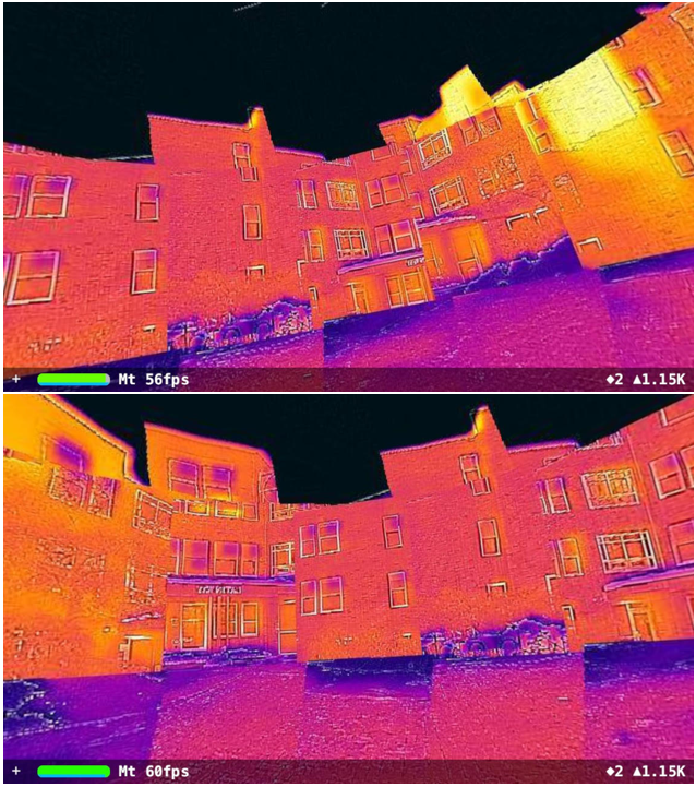
200 students in this exploratory phase. The project will develop SmartIR, a smartphone app that will guide users to collect IR images on both Android and iOS platforms for synthesizing a seamless street view. Figure 1 shows a prototype of the Infrared Street View and Figure 2 shows a little math behind the scenes.

Fig. 1: A hemispherical infrared street view (prototype)
In essence, an IR camera serves as a high-throughput data acquisition instrument that collects thousands of temperature data points each time a picture is taken. With this incredible tool, youth can collect massive geotagged thermal data that have considerable scientific and educational value for visualizing energy usage and improving energy efficiency at all levels. The Infrared Street View program will provide a Web-based platform for youth and anyone interested in energy efficiency to view and analyze the aggregated data to identify possible energy losses. By sharing their scientific findings with stakeholders, youth will make changes to the way energy is being used. 

We are completely aware of possible legal implications and complications of the proposed citizen science program. In the case of Kyllo v. United States in 2001,  the Supreme Court has ruled that the use of a thermal camera from a public vantage point to monitor the radiation of heat from a person's home was a “search” within the meaning of the Fourth Amendment, and thus required a warrant. The ruling seems to be limited to the use of thermal cameras by law enforcement, however. Back then, IR cameras were available to only a handful of professionals, but they are only $200 nowadays and just a few clicks away on Amazon. The widespread use of smartphone-based IR cameras is making thermal images commonplace on the Internet and it is probably an interesting question for law scholars to study how civilian use of IR cameras should be regulated.

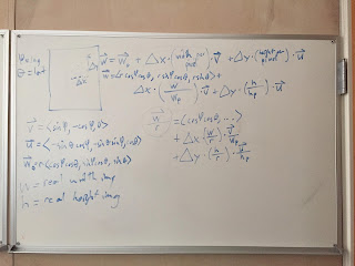
Fig. 2: Math behind the scenes.
Regardless, we will take the privacy issue very seriously and will take every precaution that we can think of to avoid potential side effects resulted from this well-intentioned program. Fortunately, we have a lot of public supports to conduct this research on large public buildings and possible commercial buildings, where the concerns of privacy are far less than private residential buildings and the needs to reduce the energy waste of those buildings and save taxpayer dollars are far more pressing. Hence, we will start with school, public, and commercial buildings in selected areas where performing thermal scan of the buildings and publishing their thermal images for educational and research purposes are permitted by school leaders, town officials, and property owners.  

From a broader perspective, the Infrared Street View program could serve as a pilot test that may shed light on increasingly important issues related to citizen privacy in the era of the Internet of Things (IoT), which features the ubiquity of sensor data collection that could be viewed by many as invasive into their physical space (not just cyberspace). While no one can deny the tremendous potential of the technology in transforming the ways people learn, work, and live, careful research must be carried out to address legitimate concerns. This program could be one of those projects that provide a unique approach to meet those challenges from a citizen science point of view, which integrates many interesting scientific, technical, educational, and legal aspects. The lessons we can learn from conducting this work could be very useful to the citizen science community in the IoT era.

Wednesday, August 16, 2017

Canadian researchers use Energy3D to design renewable energy systems for mobile hospitals in Libya

Fig. 1: A H-shaped mobile hospital designed using Energy3D
Prof. Tariq Iqbal and his student Emadeddin Hussein from the Department of Electrical and Computer Engineering at the Memorial University of Newfoundland in Canada published a paper in the Journal of Clean Energy Technologies titled with "Design of Renewable Energy System for a Mobile Hospital in Libya."

The researchers recognized that the United Nations' efforts to provide field hospitals have recently decreased in areas that face a high risk in transportation, lack of power, and lack of security for field officers, such as war-torn countries like Libya and Syria. In those unfortunate parts of the world, lack of aids and health resources have a major effect on people's lives. Their paper proposes a photovoltaics (PV) hybrid system for supplying an electric load of a mobile hospital in an area where there is no grid. Such a hybrid system is believed to be a cost-effective solution to power a mobile hospital capable of providing uninterrupted power to support a doctor and two nurses.

Our Energy3D software was used in their research as a simulation tool to study the heat load and optimize the design solution. Figure 1 shows a H-shaped design from their paper (I guess the H-shape was chosen because it is the initial of the word "hospital").

Fig. 2: Energy3D supports 450 regions from 117 countries.
We highly appreciate the researchers' efforts in finding ways to help people living in remote areas and war zones in the world. We are glad to learn that our software may have helped a bit in providing humanitarian aids to those people. Inspired by their work, we will add more weather data to Energy3D to cover areas in the state of unrest (455 regions from 120 countries are currently supported in Energy3D, as shown in Figure 2). In the future, we will also develop curriculum materials and design challenges to engage students all over the world to join these humanitarian efforts through our global drive and outreach.

Friday, August 4, 2017

Polish researchers independently validated Energy3D with Building Energy Simulation Test (BESTEST)

Fig. 1: BESTEST600 test case
Fig. 2: Comparison of Energy3D results with those of other simulation tools
The Building Energy Simulation Test (BESTEST) is a test developed by the International Energy Agency for evaluating various building energy simulation tools, such as EnergyPlus, BLAST, DOE2, COMFIE, ESP-r, SERIRES, S3PAS, TASE, HOT2000, and TRNSYS. The methodology is based on a combination of empirical validation, analytical verification, and comparative analysis techniques. A method was developed to systematically test whole building energy simulation programs. Geometrically simple cases, such as cases BESTEST600 to 650, are used to test the ability of a subject program to model effects such as thermal mass, direct solar gain windows, shading devices, infiltration, internal heat gain, sunspaces, earth coupling, and setback thermostat control. The BESTEST procedure has been used by most building simulation software developers as part of their standard quality control program. More information about BESTEST can be found at the U.S. Department of Energy's website.

Prof. Dr. Robert Gajewski, Head of Division of Computing in Civil Engineering, Faculty of Civil Engineering, Warsaw University of Technology, and his student Paweł Pieniążek recently used BESTEST600-630 test case (Figure 1) to evaluate the quality of Energy3D's predictions of heating and cooling costs of buildings. By comparing Energy3D's results with those from major building energy simulation tools (Figure 2), they concluded that, "[Energy3D] proved to be an excellent tool for qualitative and quantitative analysis of buildings. Such a program can be an excellent part of a computer supported design environment which takes into account also energy considerations."

Their paper was published here.

Tuesday, August 1, 2017

Modeling parabolic dish Stirling engines in Energy3D

Fig. 1: A parabolic dish Stirling engine
Fig. 2: The Tooele Army Depot solar project in Utah
A parabolic dish Stirling engine is a concentrated solar power (CSP) generating system that consists of a stand-alone parabolic dish reflector focusing sunlight onto a receiver positioned at the parabolic dish's focal point. The dish tracks the sun along two axes to ensure that it always faces the sun for the maximal input (for photovoltaic solar panels, this type of tracker is typically known as dual-axis azimuth-altitude tracker, or AADAT). The working fluid in the receiver is heated to 250–700 °C and then used by a Stirling engine to generate power. A Stirling engine is a heat engine that operates by cyclic compression and expansion of air or other gas (the working fluid) at different temperatures, such that there is a net conversion of thermal energy to mechanical work. The amazing Stirling engine was invented 201 years ago(!). You can see an infrared view of a Stirling engine at work in a blog article I posted early last year.

Although parabolic dish systems have not been deployed at a large scale -- compared with its parabolic trough cousin and possibly due to the same reason that AADAT is not popular in photovoltaic solar farms because of its higher installation and maintenance costs, they nonetheless provide solar-to-electric efficiency above 30%, higher than any photovoltaic solar panel in the market as of 2017.

In Version 7.2.2 of Energy3D, I have added the modeling capabilities for designing and analyzing parabolic dish engines (Figure 1). Figure 2 shows an Energy3D model of the Tooele Army Depot project in Utah. The solar power plant consists of 429 dishes, each having an aperture area of 35 square meters and outputting 3.5 kW of power.

Fig. 3: All four types of real-world CSP projects modeled in Energy3D
With this new addition, all four types of main CSP technologies -- solar towers, linear Fresnel reflectors, parabolic troughs, and parabolic dishes, have been supported in Energy3D (Figure 3). Together with its advancing ability to model photovoltaic solar power, these new features have made Energy3D one of the most comprehensive and powerful solar design and simulation software tools in the world, delivering my promise made about a year ago to model all major solar power engineering solutions in Energy3D.

An afterthought: We can regard a power tower as a large Fresnel version of a parabolic dish and the compact linear Fresnel reflectors as a large Fresnel version of a parabolic trough. Hence, all four concentrated solar power solutions are based on parabolic reflection, but with different nonimaging optical designs that strike the balance between cost and efficiency.